Showing posts with label Setting. Show all posts

Wednesday, April 10, 2013

Not quite fictional geography


It’s rare that I’m pulled into a book simply because of it’s cover (don’t judge a book and all that crap…). But I’ve been intrigued by Jess Walter’s Beautiful Ruins  ever since I first laid eyes on it. That’s a gorgeous book. One of these days I’m going to have to pick it up and give it a whirl.

According to the first few pages on the Amazon preview, the action opens in the “brutto  fishing village of Porto Vergogna,” a fictional sixth, cliff-side town along the famous Cinque Terre section of the Italian Riviera. The book’s own, hand-drawn map puts the imaginary village just south of Riomaggiore, where you'll find nothing but boring, scruffy-looking hillsides sloping into the water. 

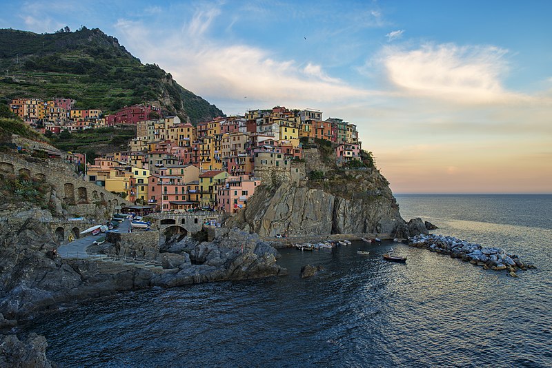
But before you give up on visiting this little piece of book-cover-paradise, I thought I’d point out that that mesmerizing cover image is actually a shot of Manarola- the 4th of 5 real-life villages running north to south along the coast.


Thursday, March 21, 2013

Mapping Don Quixote


I’m a bit of a map freak. I could look at maps all day long. And as you’ve probably noticed by now, placing the fiction I read into its real-world, geographical context is something I really. find. interesting.

But Don Quixote presents its readers with a real quandary. You can find a few modern maps that purport to track parts of the journey of Quixote and his squire, and you can find some travel pages that will tell you “These are the very windmills that inspired Cervantes’ classic,” but let’s be honest. This thing’s over four hundred years old. And even the few maps that were drawn in the 17th, 18th and 19th centuries don’t generally agree on all the landmarks (here is a great resource to skim through.)

But of those maps that show the full view of all three “sallies,” or journeys, covered in the book, there are two that match up sort of closely. This one, published in the first edition of Don Quixote for the Royal Academy of Spain in 1780, shows the one-way journeys (or round-trip journeys that assume returns along the same paths). By the way, this one can be blown up huge if you click through on the image:


This second one, from 1798, shows a more meandering loop for each of the sallies, but generally covers the same ground:


But both maps are zoomed in pretty closely, so it’s hard to see exactly where in Spain the action is unfolding. So, for your viewing pleasure, here are the same two routes, superimposed on the Iberian Peninsula. Green marks the first sally. Red marks the second. And blue marks the third. Do with these what you will.


Wednesday, January 23, 2013

The Real Winesburg, Ohio

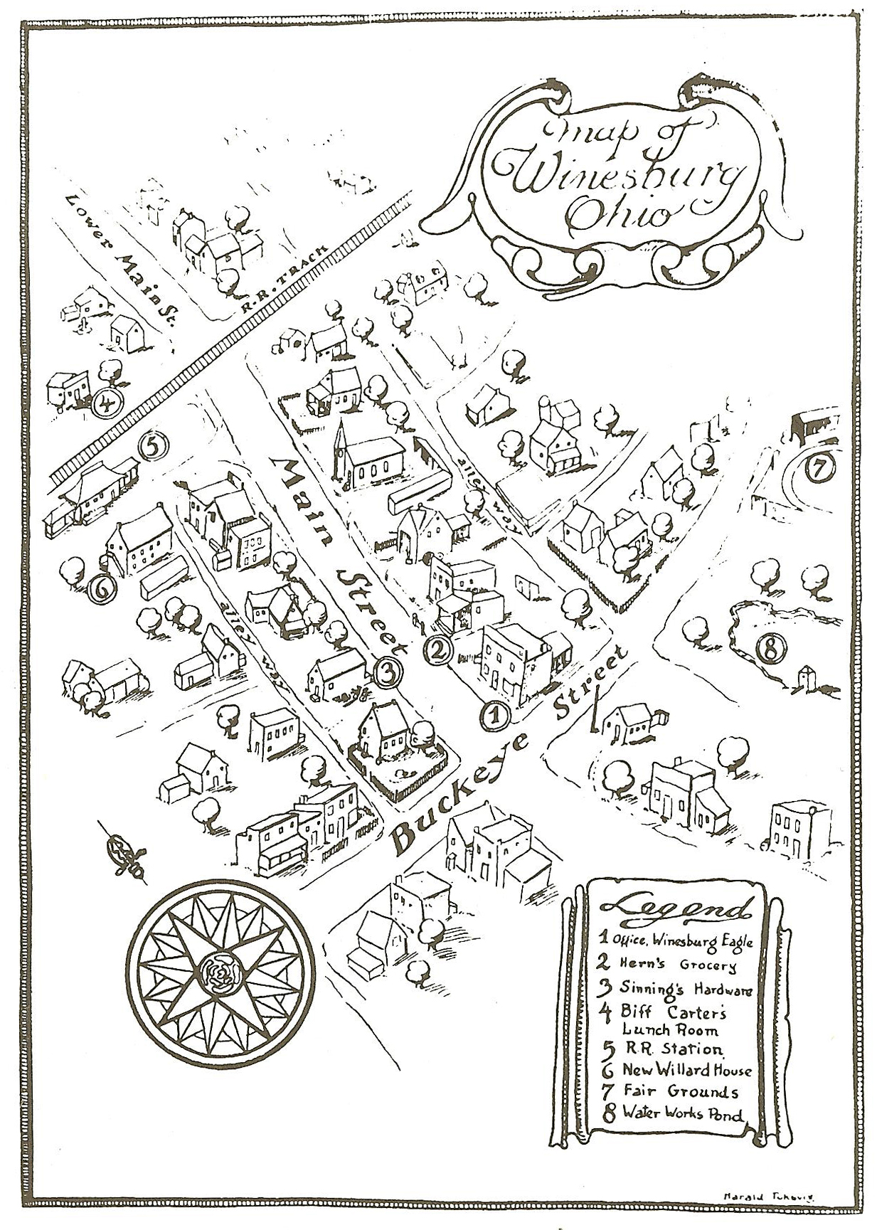
Immediately upon opening the book, readers of Sherwood Anderson’s Winesburg, Ohio  are greeted by a hand-drawn map of the fictional town that is the novel’s setting:

Turns out Winesburg was a thinly veiled representation of Anderson’s own hometown of Clyde, Ohio which, like its fictional counterpart, has a Main Street that crosses Buckeye Street and some railroad tracks a little further north. If you’ve read this post or this post, you know where I’m going with this. Here is what Clyde, OH looks like today:


The distances in the map of Winesburg are deceptively short (a half dozen structures fill the stretch between Buckeye and the Train tracks, a span that reaches a 1000 feet in the real world) and there’s not much in terms of landmarks that would jump out and link the two maps. Not even the train station or fairgrounds remain. But you can zoom all the way in and use Google’s Street View to at least stroll along Main and see some of the older buildings that might  have stood in Anderson’s time (Not likely, since he lived there from 1884-1896, but still worth a glance.)


Tuesday, November 27, 2012

The Good Earth: Found!

Our post from the other day about Cojimar got me thinking about the setting of another book I just finished: Pearl Buck’s The Good Earth . Spend five minutes with your favorite search engine and you can learn all sorts of things about that book- that it led the bestsellers lists for 21 months, that it nabbed a Pulitzer Prize, and that it was the basis of Buck’s Nobel Prize just a few years later. But if you want to know where the book actually takes place, well, that’s a little tougher to come by.

For one thing, Latin spellings of Chinese place names have changed over time, so pulling clues from Buck’s novel can be a little tricky. For another, those Latin spellings are at best just approximations of the actual Chinese pronunciation, so if you find in a biographical sketch that Buck and her husband lived in Nanhsuchou in the farming country of northern Anhwei, you might find that Google Maps suggests instead the town of nan suzhou , in Anhui  province. As it turns out, that is the correct answer, as you’ll see in a minute. And kudos to Oprah’s Book Club for putting together what appears to be the only map on the internet that tries to answer the question:


Now, as maps go, this one’s pretty crappy. Everything to the right of that right-most squiggle is actually ocean, so you’ll have to use your mind’s eye to paint it blue. And the coastline won't match what you see on any decent globe. There’s also no sense of scale except for the relative scale between cities- cities that are, again, somewhat difficult to find on a modern map with modern place names. But Shanghai is still Shanghai, so we can start our search pretty confidently from there. The Oprah Book Club (OBC) city of Chinkiang is most likely the Google Maps (GM) city of Zhenjiang. And the OBC city of Nanking is almost certainly the GM city of Nanjing. It would appear, then, that the OBC map’s ordinal directions are also pretty skewed, since in the real world Nanking/Nanjing is northwest from Shanghai, and not due west as shown in the OBC map. But okay, they tried.


Now, Nanking is about equidistant from Shanghai and Wang Lung’s farm on the OBC map, so we know that the OBC city of Nanhsuchou cannot be the GM city of Chuzhou- it’s too close to Nanking. If we keep searching to the north and west we come upon the GM city of Suzhou (different from the famous canal city near Shanghai). And here, I am fairly confident that we have pinpointed the setting of The Good Earth :

Why? Well, here’s what we know from the book itself:
  • Wang Lung’s farm is frequently flooded by a “river to the North.” A farm on the northern outskirts of Suzhou, with the Xinbian River flowing just to the north, would fit that description (The Xinbian River is not shown on the OBC map but can be seen at the top of the map below.)
  • During the first great famine Wang Lung travels southward 100 miles by train to the great cities of the South. What cities would fit this description and distance any better than the great cities on the banks of the Yangtze River: Nanjing, Zhenjiang and Shanghai?
  • Last of all, the clincher: We know that the town closest to Wang Lung’s farm is surrounded by a mote- he crosses it, he buys land next to it, etc. It can hardly be a coincidence that the old town of Suzhou just happens to be surrounded by a moat. (See the roughly rectangular outline to the left of the Suzhou railway station in the map below. Somewhere outside of that moat was Wang Lung's farming village, and somewhere inside it was the great house of Hwang and the Tea House where he meets Lotus.)
Pretty cool, no?


View Larger Map


Wednesday, November 21, 2012

Where Santiago and Manolin fished


Hemingway’s The Old Man and the Sea  was originally published in LIFE Magazine. They sent a photographer to Cuba to capture images of the author and the Caribbean island that inspired the novella’s setting. Above is his shot of Cojimar, the small fishing village northeast of Havana, that served as Santiago’s home harbor- the one that also inspired this famous first edition cover art:


Thursday, August 23, 2012

The Travel Narrative: In pictures

You thought I was done with this theme? Well, maybe just one more post. Here are a few literary journeys for those of you with a cartographer’s bent. 


From On the Road,  Sal Paradise’s path through the US and Mexico:


Steinbeck’s rambling jaunt from Travels with Charley:


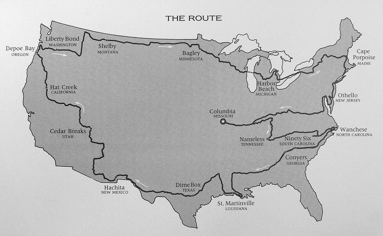
William Least Heat Moon’s roundabout roamings in Blue Highways:


The ill-fated wanderings of  Alexander Supertramp (Chris McCandless), from Krakauer’s Into the Wild:


The Pequod’s journey on the high seas in Moby Dick:


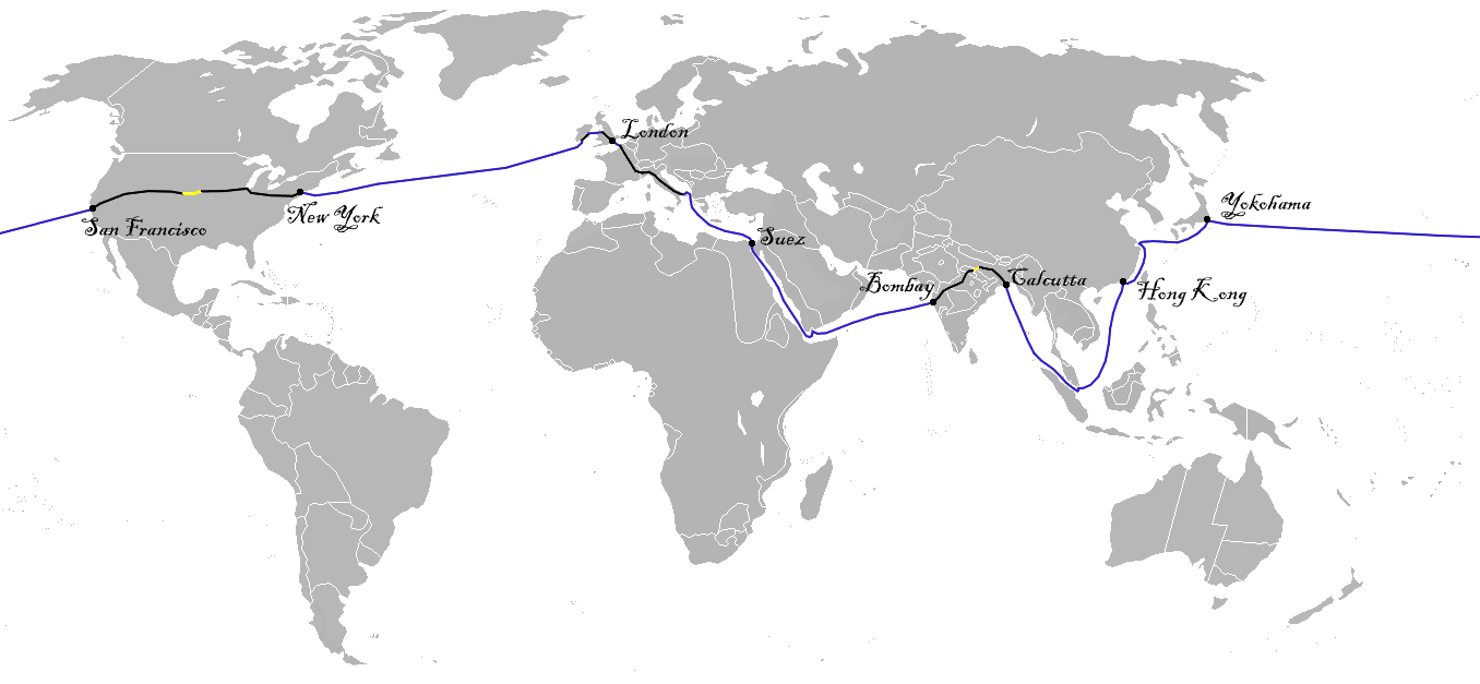
And Phileas Fogg’s mad race across the globe in Around the World in 80 Days:


What other great literary maps are we missing?